Provincial, Regional, & Intermunicipal Documents
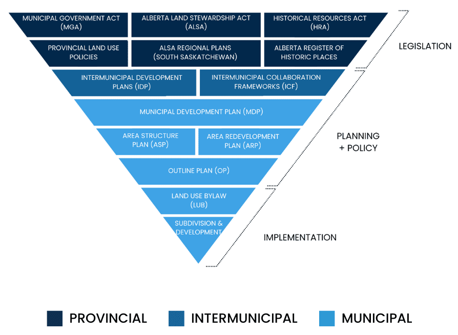
PLANNING LEGISLATIVE FRAMEWORK
The planning legislative framework in Alberta is structured like a pyramid,
with broad provincial legislation and policies at the top and detailed local
implementation tools at the bottom. At the highest level are acts such as
the Municipal Government Act and Alberta Land Stewardship Act, which
set the legal foundation. Below these are provincial and regional policies,
followed by intermunicipal plans and municipal statutory plans like the
Municipal Development Plan (MDP). Further down are more detailed plans
such as Area Structure Plans (ASP) and Area Redevelopment Plans (ARP),
then the Land Use Bylaw, and finally, at the base, the operational tools like
subdivision approvals, development permits, and building permits that
implement the vision on the ground.
Statutory plans are formal documents that municipalities are required to adopt under the Municipal Government Act to support long-term planning and development.
Non-statutory documents offer additional planning guidance and may include plans, policies, or design guidelines. While not required under legislation, they are used to support decision-making in alignment with statutory plans and the Land Use Bylaw.
PROVINCIAL LEGISLATION
ALBERTA LAND STEWARDSHIP ACT (ALSA)
The Alberta Land Stewardship Act sets out the legal basis for regional planning in Alberta and mandates that all local government bodies’ regulatory instruments must be in compliance with the applicable regional plans.
MUNICIPAL GOVERNMENT ACT (MGA)
The Municipal Government Act is the legislative framework in which all municipalities and municipal entities across the Province of Alberta operate. Under the Municipal Government Act (MGA), municipalities are responsible for providing good government; services, facilities or other things that, in the opinion of council, are necessary or desirable for all or a part of the municipality; and to develop and maintain safe and viable communities.
HISTORIC RESOURCES ACT (HRA)
Provides for the use, designation and protection of historic resources, including palaeontological, archaeological, historic or natural sites, structures or objects. Provides mechanisms for designating provincial or municipal historic resources, establishing provincial or municipal historic areas, and naming geographical features. Governs research permits, title to archaeological and palaeontological resources, and transport of historic resources out of Alberta.
PROVINCIAL LAND USE POLICIES
These are high-level policies established under Alberta’s Municipal Government Act to guide municipalities in harmonizing local planning with provincial objectives.
ALSA REGIONAL PLANS - SOUTH SASKATCHEWAN REGIONAL PLAN (SSRP)
The Government of Alberta has identified seven planning regions under the Land-use Framework (LUF), which are based on the province’s major watersheds. These plans are developed for each region that integrates provincial policies and regional land use objectives, providing the context for future decision making. The South Saskatchewan Regional Plan establishes a long-term vision for the South Saskatchewan Region and aligns provincial policies at the regional level to balance Alberta’s economic, environmental and social goals. The regional plan also includes strategies for responsible energy development, sustainable farming and ranching, recreation, forest management, and nature-based tourism.
INTERMUNICIPAL DEVELOPMENT PLANS AND FRAMEWORKS (STATUTORY AND NON-STATUTORY)
INTERMUNICIPAL DEVELOPMENT PLAN (IDP)
An Intermunicipal Development Plan is a statutory plan that must be adopted by two or more adjacent municipalities. It outlines how these municipalities will coordinate their planning for future land use, development, transportation systems, intermunicipal programs, and environmental matters in the shared area.
CALGARY-CHESTERMERE INTERFACE INTERMUNICIPAL DEVELOPMENT PLAN (IDP)
The Calgary Chestermere IDP was developed jointly by The City of Calgary (Calgary) and The City of Chestermere (Chestermere) as a common vision and framework for development along the common boundary, Range Road 284/116 Street E (Interface Street). The vision for The Plan emphasizes the pedestrian experience by supporting high-quality residential areas, vibrant mixed-use Nodes, gathering areas near Natural Features and all modes of travel.
INTERMUNICIPAL COLLABORATION FRAMEWORK (ICF)
An Intermunicipal Collaboration Framework is a tool to facilitate and encourage cooperation and cost-sharing between neighbouring municipalities in order to ensure municipal services are provided to residents efficiently.
MUNICIPAL, LAND USE, AND DEVELOPMENT (STATUATORY AND NON-STATUATORY)
MUNICIPAL DEVELOPMENT PLAN (MDP) - STATUTORY
A statutory document required by the provincial government for municipalities. The MDP is the highest-level municipal statutory document that serves as a comprehensive, long-term blueprint for land use and development within a municipality.
MASTER AREA STRUCTURE PLAN (MASP) - STATUTORY
A high-level planning document and highlight significant development considerations to guide more detailed ASP and Outline Plan development.
AREA STRUCTURE PLAN (ASP) - STATUTORY
A statutory plan adopted by a municipality by bylaw in accordance with the Municipal Government Act to provide a framework for the subsequent subdivision and development of a defined area of land.
OUTLINE PLAN (OP) - NON-STATUTORY
A detailed planning document that outlines the proposed development and land use for a specific area within the City. It serves as an intermediary step in the planning process, providing a framework for the development of land by detailing the layout, infrastructure, and services required.
LAND USE BYLAW (LUB)
A Land Use Bylaw (LUB) is a legislative document that outlines the rules and regulations for the development and use of land and buildings within a municipality for each land use district and identifies the process and decision-making authority for land use redesignations, subdivision, and development permit applications.
CONTACT THE PLANNING DEPARTMENT
BY PHONE
403-207-7075
BY EMAIL
planninginfo@chestermere.ca
IN PERSON
Monday – Friday (excluding holidays) 8:30 a.m. – 4:30 p.m.
2nd Floor City Hall
105 Marina Road, Chestermere, Alberta T1X 1V7